From waterway bank to drinking water: how recharge really happens.
The Edwards Aquifer doesn't fill from rainfall soaking evenly into the ground — it fills mostly through waterways and rivers losing their flow into fractured limestone as they cross the recharge zone. What grows along those waterways decides how much water gets there, and how clean it is.
Rainfall on the upland sheds toward the waterway. The riparian buffer slows and filters it. The waterway then loses flow through karst features directly into the aquifer.
What is a riparian zone?
A riparian zone is the strip of land directly bordering a waterway, stream, or river, where the water table stays close enough to the surface to support distinct, moisture-loving plant communities — cypress and sycamore overhead, buttonbush and switchgrass at the water's edge, sedges rooted right into the bank.
That vegetation does mechanical and biological work that nothing else replaces: root systems hold soil in place through flood flows, canopy shades the water to keep it cool for fish and invertebrates, leaf litter feeds the aquatic food web, and stems and roots slow overland flow enough for sediment and nutrients to drop out before reaching the channel.
What is the Edwards Aquifer recharge zone?
The recharge zone is the band of Central Texas where the Edwards Limestone is exposed or near-surface, fractured and pocked with sinkholes, caves, and swallets. Waterways crossing this zone — including stretches of the Blanco River, Cypress Creek, the Guadalupe River, and dozens of smaller tributaries — often lose most or all of their flow directly underground before continuing downstream.
That makes the aquifer unusually exposed to whatever happens upstream in the contributing zone. There's little soil to filter pollutants the way a deep aquifer's overlying strata would. A clean, vegetated waterway arriving at the recharge zone is doing the filtering job that geology doesn't.
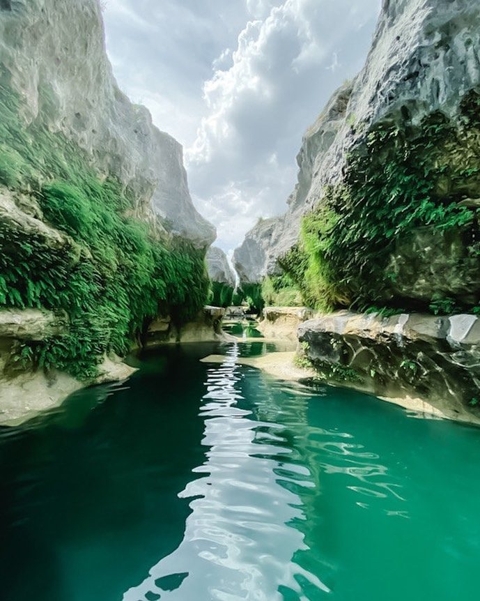
Exposed, fractured limestone like this is where surface water becomes groundwater — the physical reason the recharge zone is so sensitive to what's happening upstream.
What a riparian buffer actually does
Filtration
Dense root mats and leaf litter trap sediment, fertilizer, pet waste, and motor oil carried in runoff before they reach the channel — keeping them out of both the waterway and the aquifer it feeds.
Bank stabilization
Deep, interlocking root systems — especially from bald cypress, sycamore, and native sedges — hold streambanks together through flash floods that would otherwise carve and collapse bare banks.
Temperature control
Canopy shade keeps water cool enough for native fish, salamanders, and the endangered species found in Comal and San Marcos Springs, which depend on stable, cold spring flow.
Flood attenuation
Vegetated floodplains slow and spread floodwater rather than channeling it downstream at full force, reducing peak flows and giving water more time and surface area to infiltrate.
Recharge enhancement
Slower, cleaner, more sustained flow across karst features means more water has the opportunity to enter the aquifer rather than rushing past exposed recharge points during a single flood pulse.
Habitat & biodiversity
Riparian corridors are the most biodiverse habitat type in the Hill Country, used by everything from golden-cheeked warblers to Guadalupe bass as travel corridors and nesting ground.
What threatens riparian zones here
- Clearing for development and river views. Waterfront lots are frequently cleared to the bank line, removing exactly the vegetation doing the most protective work.
- Livestock and unmanaged grazing access. Unrestricted access lets cattle trample banks and strip young growth before it can establish.
- Invasive species. Chinaberry, ligustrum, giant reed (Arundo donax), and Johnson grass outcompete native seedlings and offer little of the same root structure or habitat value.
- Impervious cover upstream. Roads, roofs, and parking lots increase the volume and speed of runoff reaching waterways, intensifying erosion on whatever buffer remains.
- Drought and flood volatility. Central Texas's flash-flood-prone climate punishes bare banks hardest, and each flood without vegetation to anchor it can undo years of natural recovery.
Why this matters beyond the waterway
The Edwards Aquifer supplies drinking water to more than two million people in the San Antonio and Austin metro areas, along with agricultural and industrial users, and it feeds the spring systems at Comal and San Marcos that support several federally listed endangered species and two of Texas's most-visited natural swimming areas.
Because the aquifer is a karst system with limited natural filtration, degraded riparian corridors don't just hurt the waterway in front of them — they show up later as bacteria advisories, nutrient loading, and reduced spring flow miles downstream and years later.

Austin and San Antonio both draw on the same aquifer this recharge zone feeds.
See the plants that do this work
Our native plant database breaks down exactly which species we use, where, and why.